National Grid has implemented what it describes as the world’s first centralised, autonomous aerial inspection capability for electricity infrastructure, marking a significant shift in how critical power infrastructure is monitored and maintained across England and Wales.
The deployment follows four years of trials and development with sees.ai, a Chichester-based technology firm backed by Boeing. The system enables drones to conduct Beyond Visual Line of Sight (BVLOS) operations near live high-voltage infrastructure, controlled from a central command centre rather than requiring on-site operators.
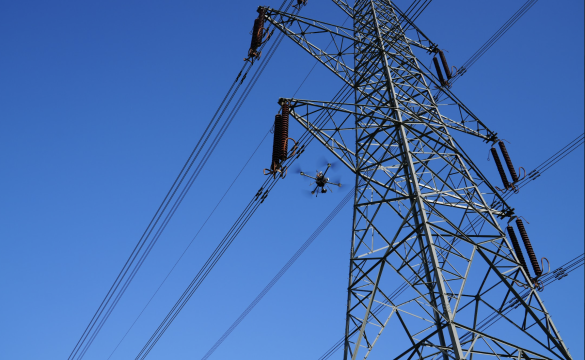
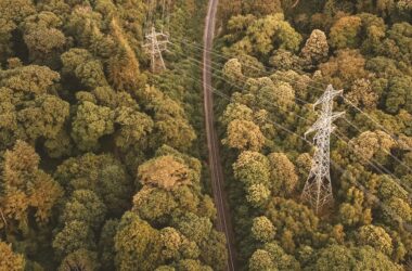
The inspection system targets National Grid’s 22,000 steel lattice towers and their associated conductors across the company’s transmission network. Drones equipped with high-resolution cameras and thermal imaging sensors capture detailed imagery of infrastructure components, providing data that informs maintenance schedules and capital investment decisions.
Unlike traditional inspection methods that require helicopter flights or technicians climbing towers, the autonomous system operates with minimal human intervention. Remote pilots in a central control room monitor the drones as they follow pre-programmed flight paths, adjusting operations as needed while the aircraft’s AI handles navigation and obstacle avoidance.
Kathryn Fairhurst, Overhead Line Operations Director at National Grid, noted that the technology enables skilled line workers to focus on complex, hands-on tasks rather than routine visual inspections. The system complements rather than replaces existing inspection methods, with helicopters and climbing teams remaining essential for specialised maintenance work.
The UK Civil Aviation Authority granted permissions for these BVLOS operations following extensive safety assessments. Sophie O’Sullivan, Director of Future Safety and Innovation at the CAA, indicated that the deployment provides essential operational data that will inform future drone regulations.
The October 2024 policy concept from the CAA enabled drones to operate beyond visual line of sight at low altitudes near infrastructure where conventional aircraft traffic is minimal. This regulatory framework positions the UK as one of the leading nations in commercial drone operations for critical infrastructure.
Engineering Deep Dive: BVLOS Operations and Infrastructure Inspection
Understanding BVLOS Technology
Beyond Visual Line of Sight (BVLOS) operations represent a fundamental shift in the deployment of uncrewed aerial vehicles. Traditional drone operations require the pilot to maintain visual contact with the aircraft, limiting inspection range to approximately 500 meters in optimal conditions. BVLOS removes this constraint through a combination of technologies that ensure safe, autonomous flight over extended distances.
The sees.ai system employs multiple redundant communication links between the drone and the control station. Primary command and control typically uses encrypted radio frequencies in dedicated spectrum allocations, while backup channels may include cellular networks where coverage permits. Real-time telemetry data streams from the aircraft include position, altitude, battery status, and system health parameters, updating at rates exceeding 10Hz to ensure responsive control.
Precise navigation near high-voltage infrastructure presents unique engineering challenges. Standard GPS provides accuracy within 2-5 meters, insufficient for operations requiring proximity to conductors and tower structures. The inspection drones likely employ Real-Time Kinematic (RTK) positioning, which uses ground-based reference stations to achieve centimetre-level accuracy.
Magnetic interference from power lines can disrupt both compass readings and GPS signals. To counter this, the aircraft integrates multiple inertial measurement units (IMUs) with sophisticated sensor fusion algorithms. These systems combine accelerometer and gyroscope data to maintain position estimates even during temporary GPS outages.
National Grid’s parallel project with the University of Manchester introduces electric field sensing capabilities to drone platforms. Power line insulators-typically constructed from glass or ceramic materials-prevent current flow from conductors to tower structures. These components generate characteristic electric field patterns during regular operation.
The e-field sensor system measures field strength and distribution patterns around insulators. Contamination, cracks, or other defects alter these patterns in predictable ways. By analysing field signatures, the system can identify degraded insulators before visible damage occurs.
Traditional insulator testing requires de-energising lines or removing units for laboratory analysis. The drone-mounted sensors operate at safe distances from energised equipment, measuring field strengths that typically range from 1 to 20 kV/m near 400 kV transmission lines. The sensors must maintain calibration despite temperature variations and electromagnetic noise from the power infrastructure itself.
Each inspection flight generates gigabytes of visual and sensor data. The sees.ai platform employs edge computing on the aircraft to perform initial data validation and compression. Critical anomaly detection algorithms run in real-time, allowing immediate identification of urgent maintenance needs.
Post-flight processing leverages machine learning models trained on thousands of inspection images. These algorithms identify specific defect types, such as corrosion patterns on steel structures, damaged conductor strands, or vegetation encroachment, allowing for targeted inspections. The AI systems achieve consistency that is impossible with human inspectors, who may interpret visual cues differently based on their experience and environmental conditions.
The platform generates georeferenced data linked to specific asset components. Each insulator, conductor span, and structural member receives a unique identifier in National Grid’s asset management database. This integration enables predictive maintenance modelling, where degradation trends inform replacement schedules before failures occur.
The centralised control architecture requires robust, low-latency communication networks. Command signals from the control room to aircraft must maintain latencies below 100 milliseconds to ensure responsive control. Video streams from inspection cameras demand bandwidth exceeding 10 Mbps for high-resolution imagery.
The system likely implements Quality of Service (quality of service) protocols to prioritise critical control commands over data streams. If communication links degrade, the aircraft executes predetermined fail-safe procedures, either returning to the launch point or landing at designated safe zones along the inspection route.
The transition to autonomous inspection delivers measurable improvements across multiple metrics. sees.ai reports a 95% reduction in carbon emissions compared to helicopter-based surveys. The consistency of automated flight paths ensures complete asset coverage, eliminating the variability inherent in manual inspections.
Cost projections indicate substantial savings, with the University of Manchester’s e-field sensor project alone expected to yield £2.8 million in savings over a 15-year period. The broader BVLOS inspection program’s economics improve as the technology scales across National Grid’s network.
The system generates what sees.ai terms “AI-ready datasets”-standardised, high-quality imagery suitable for automated analysis. This consistency enables year-over-year comparison of asset conditions, supporting data-driven maintenance strategies.
National Grid’s implementation strategy positions drone inspection as complementary to traditional methods. Helicopters continue to provide rapid response capability for storm damage assessment, while climbing teams perform complex repairs and component replacements.
The drone system excels at routine condition monitoring, particularly for components requiring frequent inspection. Insulators, conductor connections, and dampers receive regular automated surveys, with data feeding directly into National Grid’s Keen AI asset management platform.
John McKenna, CEO of sees.ai, emphasised that the contract validates the technology’s operational maturity. The company’s ground control system provides mission planning, real-time supervision, and data distribution through cloud-based portals.
If National Grid’s deployment is successful, it will establish a template for utilities worldwide. The combination of centralised control, autonomous operation, and integrated data analysis addresses the fundamental challenge of maintaining ageing infrastructure with limited resources.
The UK’s transmission network faces increasing demands as renewable energy sources require new grid connections. Efficient inspection methods become critical as the network expands to accommodate offshore wind farms and distributed solar generation.
Science Minister Lord Vallance highlighted the Government’s Regulatory Innovation Office role in reducing barriers to drone deployment. The framework developed for National Grid’s operations could accelerate adoption across other infrastructure sectors, from railways to water distribution networks.
The four-year development timeline from initial trials to full deployment demonstrates the complexity of integrating autonomous systems into critical infrastructure operations. However, successful implementation suggests that similar transformations may occur more rapidly as regulatory frameworks and operational procedures mature.
TLDR
- National Grid launches world’s first centralised autonomous drone inspection system for power infrastructure
- BVLOS operations enable inspection of 22,000+ transmission towers across England and Wales
- sees.ai technology allows remote piloting from central control room, reducing need for helicopter flights and tower climbing
- Parallel development of e-field sensors enables live insulator inspection without circuit outages
- 95% reduction in emissions compared to helicopter surveys, with projected multi-million pound savings
- Four-year trial program validates technology for business-as-usual operations
- UK CAA regulatory framework positions Britain as leader in infrastructure drone deployment