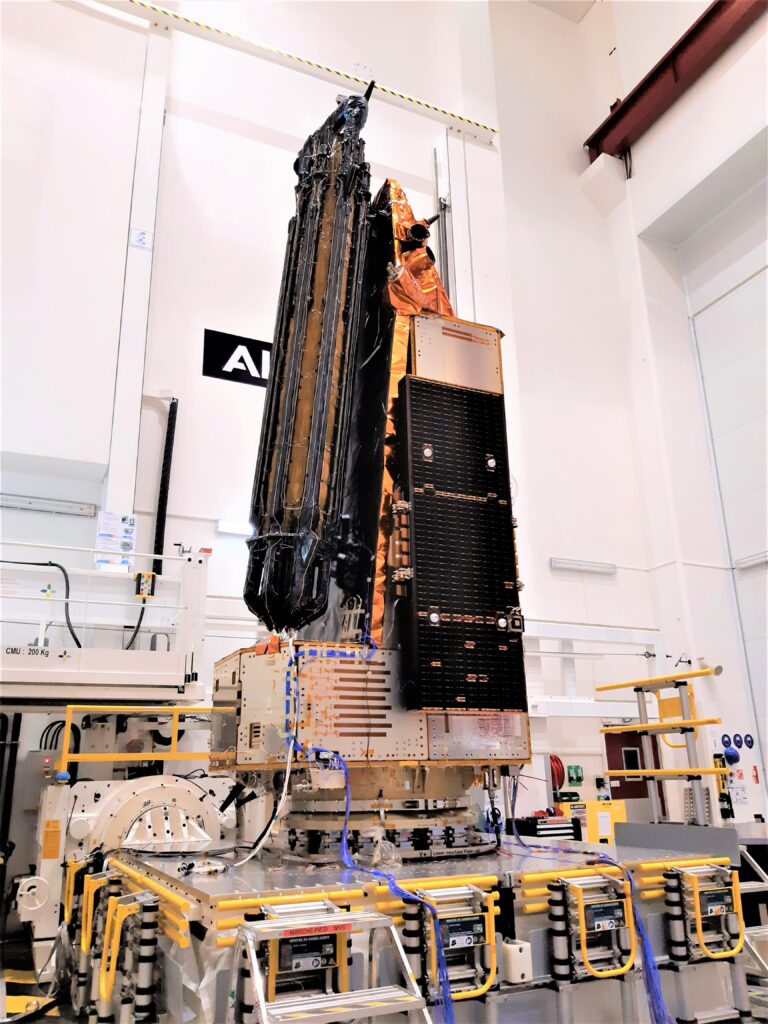
In 2024, a groundbreaking satellite called Biomass will launch into space to transform our understanding of Earth’s forests.
Constructed in the U.K. by European aerospace giant Airbus, the pioneering Biomass satellite will use state-of-the-art synthetic aperture radar (SAR) technology to create the first-ever 3D maps of global forest structure and Biomass. By measuring variables like canopy height and vegetation density from orbit, Biomass will quantify carbon stocks in forests worldwide – filling immense knowledge gaps about these complex ecosystems that cover over 30% of the planet’s land area.
The ESA hopes its datasets will provide unprecedented insight into forests’ role in the global carbon cycle and climate change.
Tracking Carbon from Space
Biomass will pioneer P-band SAR interferometry to estimate above-ground forest biomass on a global scale accurately. This measurement encompasses all living forest components, including stems, stumps, branches and foliage. By repeating scans every 6 months, Biomass can detect changes in Biomass over time – allowing researchers to track carbon fluxes as forests grow and shrink.

Synthetic aperture radar, or SAR, uses unique imaging technology to create detailed maps of the Earth’s surface. SAR interferometry, also called InSAR, compares SAR images taken at different times to detect tiny changes on the ground. Scientists have used InSAR extensively over the past 20 years, but mainly with SAR systems that use relatively short “wavelengths” of radar signals—these work well for seeing the ground in open areas without trees.
But in forests, the leaves and branches get in the way of the signals. So researchers have started testing SAR that uses longer “P-band” wavelengths that can penetrate through vegetation better. A recent study used a NASA aeroplane carrying a P-band radar system to take images of forested U.S. West Coast areas. They compared these to images from a shorter wavelength SAR on the same plane.
The P-band SAR could “see” the ground under dense forests much better. It found over 200 landslides missing from existing maps made with other methods. The longer wavelength P-band radar was also better at seeing complex landslide movement patterns under the tree cover. However, it was less sensitive to tiny slow ground motion over time.
The Biomass satellite uses this P-band SAR technology – beaming radar microwaves at forests and analysing the unique return signals – which provide information about vegetation structure and moisture content. Parameters of canopy height, sub-canopy topography, and wood volume can be derived using signal processing algorithms. Combining these variables enables accurate wide-area mapping of biomass stocks and fluxes.
The final dataset will reduce uncertainty around carbon stored in the world’s forests by almost a factor of two. This will provide vital new climate insights – significantly advancing the modelling accuracies for global carbon cycle and emissions reporting.
U.K. Innovation Leads the Way
The Biomass satellite is being built by British engineers at Airbus Defence and Space facilities in Stevenage. The project leadership also originates from the U.K., with Professor Shaun Quegan from the University of Sheffield directing the scientific elements of the mission.
Engineers have optimised the radar sensor configuration and antennas for Biomass to provide the necessary sensitivity and penetration into forest canopies at P-Band wavelengths. State-of-the-art hardware weighing over 1 tonne will be launched aboard a Vega rocket when the mission goes live.

In early 2023, Biomass finished its mechanical and environmental testing campaign, meaning the satellite is now space-qualified. Engineers simulated intense launch acoustics and vibrations to confirm that the spacecraft could withstand these harsh conditions on ascent. Follow-up deployment trials also verified that Biomass can correctly unfurl its solar arrays – generating vital power during operational orbits.
With these milestones passed, Biomass is mechanically ready for its journey to polar orbit – bringing the pioneering forest ecology mission one step closer to the scheduled 2024 launch date. Final integration and testing activities will commence before this U.K. satellite ships out for launch preparations in French Guiana.
Once in orbit, Biomass will enable new research into remote and inaccessible forest ecosystems like the vast Amazon basin. Space-based P-band radar can penetrate dense vegetation cover and reveal sub-canopy structural complexity in even the most untouched rainforest habitats.
The hope is that Biomass will revolutionise our understanding of biodiversity hotspots and carbon cycle dynamics across South America and beyond by mapping pristine habitats and quantifying their immense above-ground carbon stocks for the first time. These datasets will uncover new ecological insights while offering objective information to support conservation efforts worldwide.
TLDR:
- UK-built Biomass satellite launches in 2024 to map Earth’s forests in 3D using radar
- Will measure forest structure to estimate above-ground carbon stocks
- Led by Airbus U.K. and the University of Sheffield
- Passed recent tests showing hardware can withstand launch
- Satellite uses advanced P-band radar to penetrate forest canopies
- Will improve climate change predictions and carbon cycle knowledge
- Enables new ecological research on remote/inaccessible forests