
London-based space technology company Spaceflux has secured £5.4 million in seed funding to expand its global network of optical sensors and accelerate development of its AI-powered space tracking platform.
Founded in 2022, Spaceflux addresses the growing challenge of space situational awareness through its proprietary combination of visible and short-wave infrared imaging systems. The company’s technology enables continuous 24/7 satellite and debris tracking, addressing limitations in current space surveillance capabilities.
The round was co-led by UK Innovation & Science Seed Fund (UKI2S), Foresight Group, and Blackfinch Ventures.
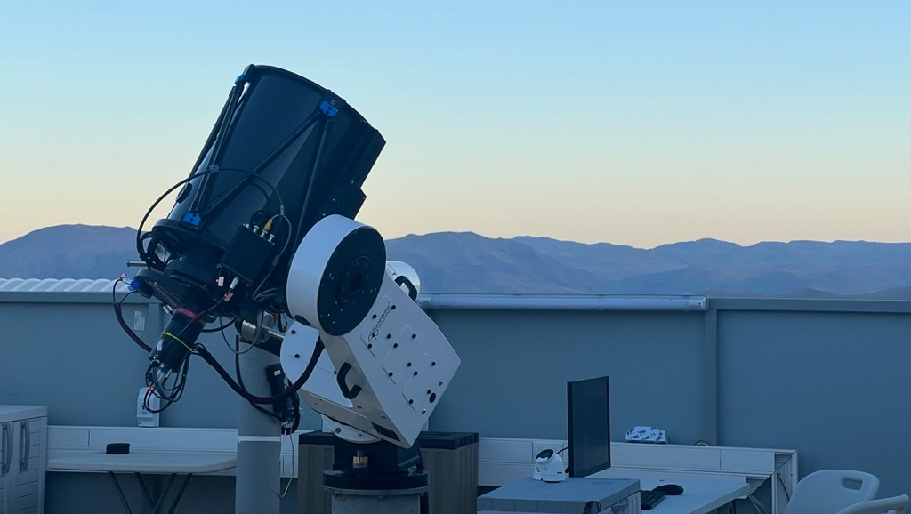
Spaceflux is differentiating itself from competitors through its dual-spectrum imaging approach, which combines visible light sensors with short-wave infrared (SWIR) technology. This promises to track space objects under both daylight and nighttime conditions, expanding the operational window beyond traditional night-only optical surveillance systems.
The ground-based sensor network tracks satellites and debris across all orbital altitudes, from low Earth orbit through geostationary regions. If successfully deployed at scale, this approach could provide more comprehensive coverage than existing radar-based tracking systems, which face limitations in detecting smaller debris objects.
The company initially focused on geostationary orbit monitoring for the UK Space Agency and Ministry of Defence, establishing its operational credentials before expanding to broader commercial applications. The new funding will enable network expansion and enhanced sensor capabilities.
Engineering Deep Dive: Optical Space Surveillance Technology
Space-based object tracking relies on two primary detection methods: radar and optical systems. Each approach presents distinct engineering challenges and capabilities that determine its effectiveness in different scenarios.
Radar-Based Detection: Traditional space surveillance networks, such as the US Space Surveillance Network, employ ground-based radar systems that transmit radio waves and analyse the reflected signals. Radar systems excel at providing precise range and velocity measurements, operating effectively in all weather conditions and times of day. However, radar detection capability diminishes significantly for objects smaller than 10 centimetres in low Earth orbit, resulting in gaps in debris tracking coverage.
The radar cross-section of an object determines its detectability, which depends on both size and material properties. Metallic objects reflect radar signals more effectively than composite materials, creating inconsistencies in detection capabilities across different satellite designs and debris types.
Optical Detection Optical tracking systems detect reflected sunlight from space objects, requiring sophisticated image processing algorithms to distinguish targets from stellar backgrounds. Traditional optical systems operate only during night hours when sunlight illuminates the target, while ground-based sensors remain in darkness.
The key innovation in Spaceflux’s approach involves short-wave infrared (SWIR) imaging, which operates in the 1.0-2.5 micrometre wavelength range. SWIR sensors can detect thermal emissions and reflected solar radiation during daylight conditions, enabling continuous tracking operations.
Signal Processing & Target Identification: Optical space surveillance generates massive datasets that require advanced processing capabilities. A single sensor can collect thousands of images per night, each of which involves analysis for potential space objects. The challenge lies in distinguishing actual targets from noise sources, including atmospheric disturbances, aircraft, and stellar objects.
Machine learning algorithms process pixel-level data to identify object signatures, tracking movement patterns across multiple frames to establish orbital parameters. Neural networks trained on known satellite behaviours can classify objects based on their type, size, and operational status.
Successful space tracking requires the integration of observation data with orbital mechanics calculations. Two-line element (TLE) sets describe satellite orbits using Keplerian parameters, but these become outdated quickly due to atmospheric drag and gravitational perturbations.
Real-time tracking systems must account for orbital decay rates, particularly for objects in low Earth orbit, where atmospheric drag causes a loss of altitude. The challenge intensifies for non-cooperative targets without active positioning systems, requiring purely observational orbital determination.
Global optical sensor networks are subject to geometric constraints due to the locations of sensors and orbital mechanics. Objects in geostationary orbit remain fixed relative to Earth’s surface, simplifying tracking from specific ground locations. However, low Earth orbit objects require coordinated observations from multiple sensor sites to maintain continuous coverage.
Atmospheric conditions significantly impact optical performance, with cloud cover, humidity, and atmospheric turbulence affecting image quality. Distributed sensor networks mitigate these limitations by providing multiple observation opportunities across different geographical locations and weather patterns.
Modern space surveillance systems employ machine learning algorithms to process large-scale sensor data. Convolutional neural networks analyse image sequences to identify moving objects, while recurrent neural networks predict future orbital positions based on observed trajectories.
The computational requirements for real-time processing demand high-performance computing infrastructure, with edge computing capabilities at sensor sites reducing data transmission requirements. Cloud-based analytics platforms enable scalable processing while maintaining low-latency response times for collision warnings.
The space surveillance sector is facing increasing pressure as orbital environments become increasingly congested. A recent UK Government report highlighted potential economic impacts, estimating that a one-week disruption to satellite navigation systems could cost £7.6 billion.
Current tracking capabilities rely heavily on US Space Force data, creating strategic dependencies for European operators.
If successful, Spaceflux’s planned object catalogue could provide alternative data sources for European satellite operators and government agencies.
The company serves multiple market segments, including satellite operators that require collision avoidance data, insurance companies assessing space asset risks, and defence agencies that monitor orbital activities. Each segment presents distinct technical requirements and operational challenges.
Spaceflux’s Cortex platform processes sensor data through AI algorithms to generate actionable intelligence for space operations. The system analyses object trajectories, predicts collision risks, and provides real-time alerts for satellite operators.
The platform integrates multiple data sources, combining proprietary sensor observations with publicly available orbital data. Machine learning algorithms identify patterns in space object behaviour, enabling predictive analytics for operational planning.
The commercial deployment of Cortex faces technical challenges in data fusion, requiring the integration of observations from distributed sensor networks with varying accuracy and update rates. The system must handle data latency issues while maintaining prediction accuracy for fast-moving objects in low Earth orbit.
The funding round highlights the overlap between commercial space technology and defence requirements. UKI2S backing demonstrates government interest in dual-use technologies that serve both commercial and national security applications.
Spaceflux’s technology addresses capability gaps in European space surveillance, potentially reducing dependence on US-provided tracking data. If geopolitical tensions affect data-sharing agreements, independent tracking capabilities become strategically crucial for European satellite operations.
The company’s initial work with the UK Space Agency and the Ministry of Defence provides operational validation for defence applications. However, scaling from government contracts to broader commercial deployment requires different technical approaches and business models.
Optical space surveillance faces inherent limitations, including weather dependencies and daylight tracking constraints. While SWIR technology extends operational windows, atmospheric conditions continue to affect system performance.
The success of Spaceflux’s approach depends on achieving sufficient sensor network density to provide reliable coverage across orbital regimes. This requires significant capital investment and international coordination for the placement of sensors.
If the company successfully deploys its planned catalogue and expands sensor networks, it could establish a competitive position in the growing space situational awareness market. However, competition from established radar networks and emerging commercial tracking services presents ongoing challenges.
The £5.4 million funding provides resources for network expansion and platform development, but long-term success requires demonstrating operational advantages over existing tracking systems. Market adoption will depend on proving superior accuracy, coverage, and cost-effectiveness compared to current solutions.
TLDR
- Spaceflux raises £5.4M seed funding for optical space tracking technology
- The company combines visible and short-wave infrared sensors for 24/7 space debris monitoring
- AI-powered Cortex platform processes sensor data for collision prediction
- Technology addresses growing space congestion with a potential £7.6B economic impact
- Funding enables global sensor network expansion and commercial platform development
- Serves satellite operators, insurers, and defence agencies with space situational awareness